
There is something intensely satisfying about looking at maps; even maps of very familiar areas inevitably reveal something new. I think I am particularly receptive to maps, as I am to floor plans. I can never really understand a space until I see the overhead schematic drawing, and I wish I could explain why. All I can articulate is that maps seem so direct that they can turn vision most immediately into knowledge, and by extension, power. To see a map is to know it and to map that area yourself, in your mind.
But of course the huge variety of maps indicates that they are not as objective as they appear. And it is that very subjectivity--the manipulation of scale, the careful selection of detail--which makes maps so beautiful. We've already seen my favorite map of DC, but here are some others of the other cities in which I've lived. (You can click on any image to see an enlarged view.)

This map of New York or "Nouvelle York" was made by a cartographer named Bellin in 1763. It was the first map of Manhattan obtainable in France, and was printed in Paris after a 1693 manuscript plan by Franquelin, made at a time when France and England were at war. The map may well have been prepared for a contemplated French invasion of the city. The wall on the north side of the town is where Wall Street now stands. The fort on the lower left gave Battery Park its name.

The Library of Congress has some great maps online that you can view close up in high resolution. This one was printed in London in 1776, drawn by the sculptor Bernard Ratzer, and inscribed to Sir Henry Moore, then the Governor of New York. You can click here to see the map in more detail.

Made in the same year, this map shows Upper, rather than Lower, Manhattan. Specifically it depicts Fort Washington, which the English renamed Fort Kniphausen when they took it during the Revolutionary War. In fact, this map was drawn by C. J. Sauthier on November 16 under the orders of the Earl of Percy, to commemorate the victory that he led there on the same day.

Here's a nice map of Manhattan in its entirety. It was published in New York in 1836 and shows the extent of settlement in Lower Manhattan as well as topographical details. Click here to see the map in more detail, its worth it!

And to round out our Manhattan maps, I just couldn't resist this beautifully drawn birds-eye view of the city, which dates from the very early twentieth century.

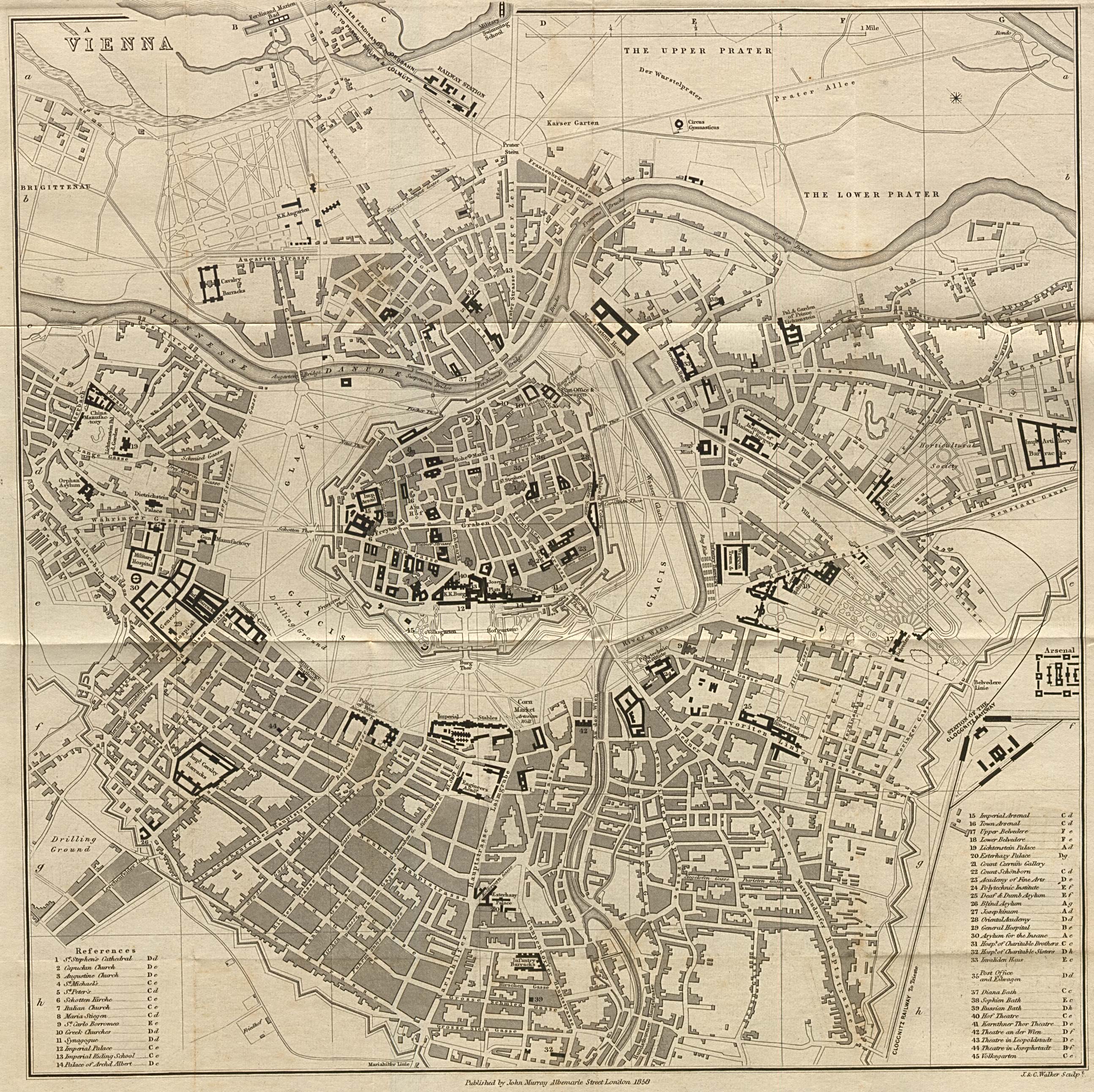
This is a truly fabulous map of Vienna, where I lived for four months. It was published in 1858 in the eighth edition of A Handbook for Travellers in Southern Germany by John Murray (this was before German unification when "Germany" had a much broader definition). You can clearly see the Danube snaking along the top and the distinctive urban plan. At the center, the old city is surrounded by walls and a swath of land shown in white. The walls were not torn down until the late nineteenth century when the Ring Strasse, a series of boulevards, was built in their place. The outer edge of the town shown here became "the Belt," another series of bustling, more commercial, boulevards. You can click here to zoom in on the map and see everything labeled in English.

After Vienna I spent another four months in Paris, shown in this map by Nicolas de Fer that dates from the late seventeenth or early eighteenth century--before Hausmannization! Again, you can see the map in more detail here. A little treat for my francophile friends!

3 comments:
This is great info to know.
Hi
Enjoyed your maps. I also have a map of Vienna. It's from 1703 and shows the city as a walled city. Also visible are the trenches dug by the turks in 1682 in preparation for the Battle of Vienna in 1683 which marked the beginning of the end of the Ottoman Empire. I've had the map for decades but only recently began to study it and learn the history of that region.
Your blog keeps getting better and better! Your older articles are not as good as newer ones you have a lot more creativity and originality now keep it up!
Post a Comment